

Among the many puzzles of human history, few are as intriguing as the claim that ancient maps depict Antarctica free of ice — thousands of years before modern exploration. Could early civilizations have possessed advanced geographical knowledge that was later forgotten? Or are these maps simply the product of coincidence, misinterpretation, or artistic license?
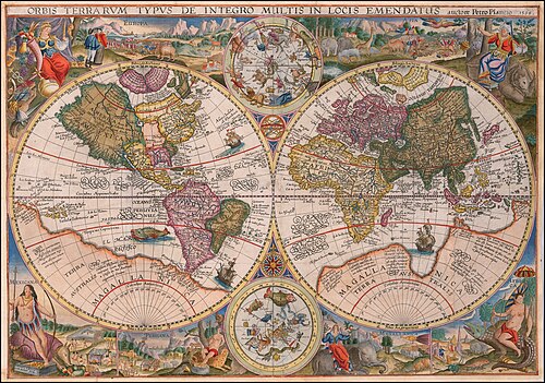
The most famous of these mysterious documents is the Piri Reis Map, a 16th-century chart that appears to outline the coast of Antarctica — centuries before the continent’s official discovery in 1820. Let’s unravel the debate and explore whether these maps point to lost knowledge or historical happenstance.
The Piri Reis Map: A Historical Enigma
In 1929, researchers discovered a fragment of a world map drawn by Ottoman admiral Piri Reis in 1513. Using sources ranging from Portuguese explorers to much older charts, the map astonished historians for one reason:
- It seemed to depict the southern coastline of South America and an ice-free Antarctic Peninsula.
- The accuracy of the latitudes and coastal details shocked experts, given the limited tools of the early 16th century.
If true, this suggested that ancient seafarers charted Antarctica long before it was buried under ice sheets.
Antarctica and the Ice Question
Scientists estimate that Antarctica has been covered in thick ice for at least 14 million years. However, satellite surveys show that some coastal areas may have been ice-free as recently as 6,000 years ago.
- This aligns with the end of the last Ice Age, when sea levels rose dramatically.
- If ancient civilizations had advanced navigation and seafaring skills, they could theoretically have mapped these regions before glaciers advanced again.
This tantalizing possibility fuels the debate: could forgotten cultures have possessed knowledge of Earth’s geography that rivals our own?
Other Ancient Maps That Raise Eyebrows
While the Piri Reis Map is the most famous, it is not alone:
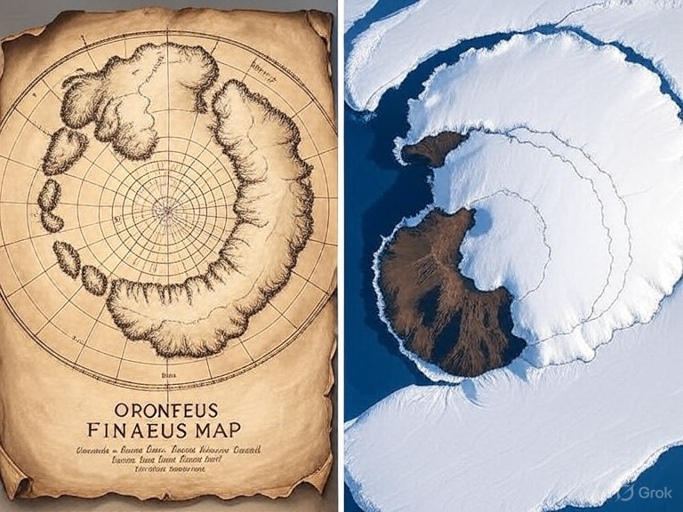
- Oronteus Finaeus Map (1531): Appears to show Antarctica’s outline with rivers flowing into the sea, implying it was not fully covered in ice.
- Buache Map (18th century): Shows Antarctica split into two landmasses, similar to what modern radar surveys beneath the ice have revealed.
- Mercator Maps: Some of Gerardus Mercator’s world maps contain puzzling polar details that suggest ancient cartographic sources.
Together, these maps suggest that geographical knowledge may have been passed down through older civilizations, perhaps long before recorded history.
Mainstream Explanations
While the idea of lost civilizations mapping Antarctica is exciting, mainstream scholars caution against leaping to conclusions.
- Projection errors: Cartographers often stitched together partial maps from various sources, distorting coastlines. What looks like Antarctica could simply be South America drawn inaccurately.
- Imaginative filling: Mapmakers sometimes filled blank spaces with guesses, legends, or myths.
- Coincidence: With limited reference points, some coastal outlines might just coincidentally resemble Antarctica’s shape.
From this perspective, the “Antarctica” in these maps may be nothing more than creative errors, not evidence of lost knowledge.
Could There Have Been Lost Knowledge?
Supporters of the lost civilization theory argue differently:
- Ice-free mapping: The resemblance of certain maps to Antarctica’s subglacial features (discovered only with modern technology) suggests knowledge beyond coincidence.
- Seafaring skills: Ancient cultures like the Phoenicians, Polynesians, and Egyptians were master navigators. Could a forgotten maritime civilization have reached Antarctica?
- Oral traditions: Myths of great floods and sunken lands (like Atlantis) may preserve memories of a time when coastlines looked different.
If true, these maps may represent fragments of an advanced global knowledge system, preserved and copied over centuries.
Ancient Civilizations and Advanced Cartography
The existence of advanced cartography in antiquity isn’t as far-fetched as it seems:
- The Greeks calculated Earth’s circumference with surprising accuracy around 240 BCE.
- The Polynesians navigated thousands of miles of ocean using star charts and wave patterns.
- The Egyptians and Mesopotamians tracked celestial cycles with precision.
If these cultures achieved such feats, it is possible that even earlier societies developed advanced mapping skills — only for their knowledge to be lost after cataclysms like ice age floods or societal collapse.
Modern Science Meets Ancient Maps
Recent advances in satellite imaging and ground-penetrating radar show that Antarctica’s landscape beneath the ice resembles some ancient depictions. For instance:
- The Buache Map’s divided Antarctica matches modern knowledge of the continent’s subglacial structure.
- The Piri Reis Map’s coastal outlines line up with certain ice-free regions identified by modern surveys.
While these parallels could be coincidences, they raise provocative questions about whether ancient humans had access to detailed geographic knowledge.
Coincidence or Lost Knowledge?
At the heart of the debate lies a profound question:
- Were ancient maps simply errors, coincidences, or clever guesses?
- Or do they hint at a lost chapter of human history, when civilizations possessed advanced seafaring and cartographic skills?
Mainstream archaeology leans toward coincidence, but the evidence keeps the mystery alive. The fact that ancient maps continue to inspire debate shows how much we still don’t know about our own past.
Conclusion
The mystery of ancient maps showing Antarctica before ice remains unsolved. While many explanations point to coincidence and error, the possibility of lost knowledge cannot be dismissed entirely. The Piri Reis Map and others like it remind us that history is full of enigmas waiting to be re-examined.
Whether they reflect chance mistakes or echoes of forgotten civilizations, these maps challenge us to rethink human history — and keep the door open to the possibility that our ancestors knew more about the world than we give them credit for.
Love it!